It was an Australian long weekend. One morning, we leisurely drove from Melbourne to Mount Gambier. We had a few stops along the way, had lunch, stretched our legs and freshened up. We were not in any hurry; it was a bonding and ‘break away from routine’ trip. Six hours later we arrived at the South Australian border. South Australia is half an hour behind us so we drove into South Australia in the middle of the afternoon.
South Australia is free from the fruit fly and other pests. Bringing fruit and some vegetables into South Australia is prohibited. Quarantine disposal bins are placed near the border. Please be mindful and do the right thing.
Mount Gambier lies half way between Adelaide and Melbourne and is the second most populated city in South Australia. It is 450 kilometres from Adelaide and 17 kilometres away from the Victorian border. The land is ancient; it started a long time ago. The city is known for its geographical features, particularly its volcanic and limestone features.
Mount Gambier is 437 kilometres away from Melbourne, via the Western Freeway. Passing through Dartmoor and Hamilton, it was a nice drive all the way. It’s a place we have been to many times in the past. This time, there not many vehicles on the road. We only saw one person driving like a maniac; the rest of the drivers were good road users. At one stage, there were three long trucks in a row. Most of the cars happily drove behind them; no one was impatient. Those truck drivers kept to the speed limit; only after passing town centres were they slow to pick up speed again. That was alright; none of us wish to speed nor rush on the road. We started our trip with a positive mind frame.
The landscape became lush and vibrant with pine and native forests. We entered rich farm land which produces world famous Wagyu beef and passed award-winning wineries. If visiting in colder seasons, the green pastures would be delightful. In warmer seasons, the grassland turns brown under the influence of the hot, penetrating Australian sun. No matter how nature is displayed, visitors would feel comfortable with what Mount Gambier has to offer – the relaxation of a country town and a touch of the vibrant lifestyle of a big city. It has modern conveniences and the preservation of natural beauty. Progress and traditional culture co-exist side by side.
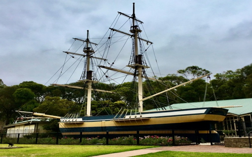
We started the next day at the outstanding looking Information Centre. A replica of the retired 60-ton sailing vessel “Lady Nelson” gracefully rests right in front of the Centre, welcoming whoever visits.
The Centre has an ossified skull of a simosthenurus occidentalis, which is an extinct kangaroo species of South Australia, on display. There is also a geology room where visitors can catch a glimpse of a volcano explosion. It also has an under-sea world, where visitors can check out interactive displays and marine creatures.
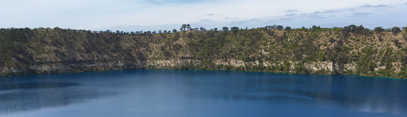
Mount Gambier is a dormant volcano. The city partially surrounds the maar complex. It’s one of Australia’s youngest volcanoes and is responsible for the town’s distinct geographic features like limestone deposits, the Blue Lake and the Valley Lake Wildlife Park. The last eruption was about 2900 BC.
The Riddoch and Main Corner Complex in the heart of the town is an exhibition and convention complex. The Riddoch Art Gallery is South Australia’s largest and oldest regional gallery. The Complex provides one-hour free screenings of two films. The first one is a short film “Craitbul”, telling the Indigenous Dreamtime story of Mount Gambier’s volcanic features. The second one – Volcano, the story of Earth, Fire and Water – is an award-winning documentary; a big screen, cinematic experience which tells the story of the eight major volcano eruptions that shaped the Kanawinka region and created Mount Gambier.
Every evening there is supposed to be a sound and light show within the Cave Gardens starting with historic photos projected onto the back of the buildings and followed by stories of local Dreamtime legends. For some reason or another, the historic photos were unviewable and the sound and light show didn’t happen at all, disappointing a few visitors. The only sounds that could be heard in the cave were the noises that the possums made.
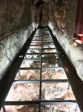
The Cave Gardens, a state heritage area, are located between the Main Corner Complex and the library. They are noted for their rose bushes, planted over a century ago. The cave can be viewed from suspended platforms and is accessible by stairs. Spectacular waterfalls occur after a downpour in the wet season.
The only accessible cave within the town limits is Engelbrecht Cave. It is one of the most visually unique caves within the Limestone Coast area. Divers swim through the water filled passages under the streets and roads of the town. It has two caverns which show the changes in underground water level and the geological characteristics of its formation.
Not all libraries are the same. Mount Gambier’s library certainly is different from the traditional ones. Since its 2009 redevelopment, the vision was for it to be the “third place” after home and work. A place for the community to gather, connect and learn. It was hailed in 2009 as “the best smaller city public library in the world”. It’s a modern building with bright space, spacious seating areas and low bookshelfs with plenty of vacant spaces. There is a children’s play area featuring a fantasy world of caves and underwater adventures for children to explore, computer games with noisy players, people talking aloud and two exercise bikes ridden by excited riders. It’s certainly not a hushed, solemn environment, nor dark with stale air. It’s interactive and innovative, more like a luxurious community centre.
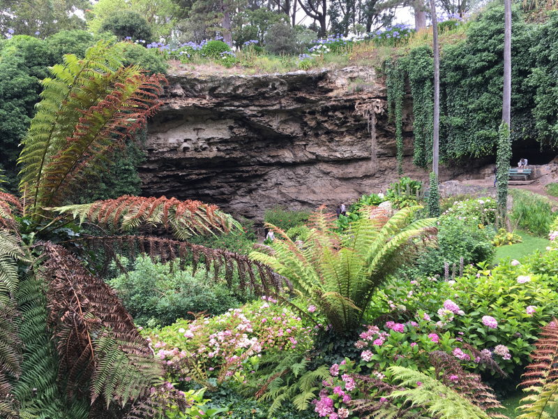
Of the many sinkholes in Mount Gambier and surrounding areas, the Umpherston Sinkhole would be the most visited one. Its location near the town centre and amazingly well maintained presentation is unbeatable. It is also known as “The Sunken Garden”. It used to be part of a limestone cave. When the ceiling of a large underground cave collapsed into itself, it left a huge pit in the ground. The town turned a disastrous natural phenomenon into beautifully manicured gardens. From the viewing platforms at the top of the sinkhole, looking down at the marvellous terraces and thick vines cascading over the sinkhole’s edge, one is impressed by its size and depth and realises how extraordinary it really is.
If you like walking, don’t miss the “City Heritage Walk”. There are 32 sites to stop at, to imagine and ponder what they were like in the past.
This is a clean and tidy town with a peaceful and relaxed atmosphere. No wonder I keep coming back to visit. Sometimes I stay for awhile, sometimes I stop for only a few hours and drive through.
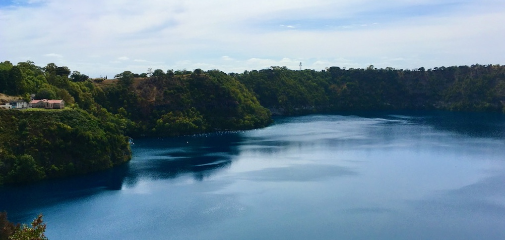
The Blue Lake is one of the most recognisable features of South Australia. It is renowned the world over for its dramatic colour change each year. It changes from a bluey grey colour to a vibrant turquoise blue in summertime. Nevertheless, the Blue Lake is beautiful all year round. A 3.6 kilometres Grand Circuit walking track around the lake is worth taking. There are many different viewing points along the track from which you can view the Blue Lake at different angles. The surrounds include a wildlife park, a caravan park, a succulent plant garden, a BBQ area and a children’s playground.
The ancient array of volcanic landscape, underground waterways and sinkholes makes a great holiday destination for city folk.
We drove into the Penambol Conservation Park and tried to visit the Caroline Sinkhole. Excavations in the sinkhole revealed evidence of the original inhabitants, the Boandik people, who were likely to have used the area for shelter. Nearby is “Hells Hole”, a large sinkhole which has existed for thousands of years. The massive 30-metre deep sinkhole is filled with dark blue fresh water. Visitors need a permit for diving. Gazing down from the viewing platform at dusk is not recommended for weak-hearted visitors. The surrounding tall and dense pine tree forest adds mystery to the air. Fifteen years after stepping away from that viewing point, I still clearly remember what “Hell” looks like. On this trip we did not have a detailed map or directions and the bumpy dirt road didn’t help. When we lost our internet connection, we got the hint and left the park. Although we were disappointed not to see the Caroline Sinkhole, we were delighted to see the young pine trees plantations which occupied a large area.
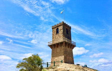
Standing 190 metres above sea level, the highest point in the area is Centenary Tower. It can be seen from many points in the town and the surrounding district. When the flag is flying from the top, it is open to visitors. After walking up a short but steep hill, we were rewarded with a 360 degree, uninterrupted, panoramic view and enjoyed the spectacular sight of volcanic craters, lakes, sand dunes, the ocean and the town.
Kingston South East
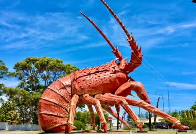
The small seaside town, Kingston SE, is about 138 kilometres away from Mount Gambier. We wanted to say hello to “Larry” while we were in this part of the country. Larry, the big lobster sculpture, is regarded as one of the most impressive of Australia’s Big Things, standing 17 metres tall, 15.2 metres long, 13.7 metres wide and weighing approximately 4 tonnes. The frame is made of steel, coated with layers of styrofoam and fibreglass. It was built in 1979 to promote South-Eastern Australian seafood, wine and cheese.
The 100 kilometre long beach reminds me of California, but it didn’t have shoulder to shoulder summer crowds, just the glary, white sand under the sun and the green coloured sea fondling the seashore. Once you put on sunglasses, it’s far better than California. At least here there are no pretentious hunters and seekers. Sightings of sea lions, seals and dolphins are also a regular occurrence. Walking on the 400 metre long jetty, the sea breeze flapping the sunhat and burning the bare skin, that’ll teach anyone who refuses to put on sunscreen. (Did I hear ‘guilty’ inside my head?)
The 41-metre-high Cape Jaffa Lighthouse took more than 3 years to build and was opened in 1872. It was erected on the Margaret Brock Reef, 8 kilometres out to sea from Cape Jaffa and 20 kilometres south west of Kingston SE. The lantern room provided a 142,000 candle power light which showed for a distance of 40 kilometres. It became Australia’s first lighthouse to be dismantled and shifted from a site at sea to be re-located and re-built on land (in 1976).
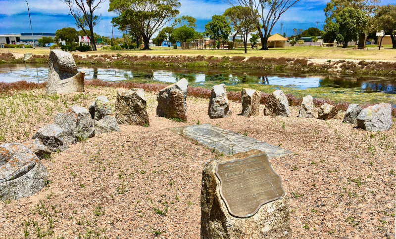
My personal favourite in this town is the “Sundial of Human Involvement”, known as an analemmatic sundial, located on a small island in Maria Creek adjacent to the Apex Park. A sundial, the earliest type of timekeeping device, indicates the time of day by the position of the shadow of some object exposed to the sun’s rays. As the day progresses, the sun moves across the sky, causing the shadow of the object to move and indicate the passage of time. Here, the object is human.
For some reason or another, this time revisiting both Mount Gambier and Kingston SE became our most relaxing holiday in these areas. Maybe it’s like re-watching a movie where your senses improve and pick up more details through re-watching, especially with some well-produced movies.
On our way back home, the conversation in the car was where to stop to have our lunch? After a pleasant time in the country, we wanted to extend our relaxed feeling to the max, before going back to the hustle and bustle of routine again. Suddenly we saw a dog, a Jack Russell Terrier, sitting right in the middle of the Glenelg Highway. It ignored our approaching car, unmoved and unaware. Caitlin quickly and safely swerved the car around the dog, stopping 400 metres away on the roadside. The dog still didn’t move. While we were deciding how to help, a few cars passed by. We couldn’t let the dog stay in the middle of the highway, so we thought the best thing to do was take it to a police station in the nearest town. When I opened the car door, the dog was standing right next to the car. I guessed it must have sensed what we were going to do and was happy with our decision. It bypassed me and went right to Caitlin as soon as she got out of the car. She wrapped a towel from the car around the dog. It calmly sat in the back seat next to Caitlin, like they had known each other for a long time. Both of them serenely enjoyed the ride, like it was part of our travel plan. I know Caitlin has a big heart for animals but I didn’t know she could handle dogs so well, where did she learn all those skills from? I looked at her in a very different light.
Caitlin found the nearest town called Casterton which just happens to be the birthplace of the Kelpie, a uniquely Australian breed of sheep dog. We drove into the town but found the police station was closed. We went for plan B when plan A was not working. It took a long few minutes to find a vet. The nice staff member at the front desk told me that she might be able to find its owner by checking for a microchip. Our hearts warmed up and we said goodbye to the dog. We thought that we might come back here to spend some time to look around the series of sculptures and take the Kelpie Walking Trail. After all it’s only 365 kilometres from Melbourne.